Google Maps is the most widely used navigation app for a reason. It’s accurate, reliable, and packed with details, but its many Google Maps icons and symbols can be confusing, especially if you don’t use the app often. These symbols highlight everything from restaurants and rail lines to temples and tourist spots. Understanding them makes it easier to find places and move around confidently.
In this guide, you’ll learn about the most important Google Maps icon meanings you’ll see on both iOS and Android devices.
What Do Various Icons and Symbols Mean on Google Maps?
To make things easy to follow, I have divided all icons and symbols into two main categories. Each category covers different pages or screens.
- Interface-Level Icons: These icons appear across Google Maps on the Home screen, Search, Directions, and Navigation views, representing the main tools that help you search, explore, and navigate.
- In-Map Icons and Symbols: Icons mark locations and points of interest on the map, such as temples, hospitals, schools, cafes, petrol pumps, bus stations, and tourist spots, each with a unique symbol.
Categories are further broken down by screens (Home, Search & History, Navigation), with detailed explanations and screenshots for clarity.
If you prefer entering an exact location instead of using icons, here’s how you can use GPS coordinates in Google Maps for precise navigation.
Category 1: Google Maps Interface Icons
Google Maps is filled with icons around the screen, not just on the map. These symbols help you search, explore, switch modes, and get directions. In this section, I’ll break down the key icons, where they appear, what they look like, and what they do.
1. Google Maps Home Screen Icons
When you open Google Maps, the Home page is your starting point for searches, directions, and nearby spots. Most key icons appear here. Let’s break them down one by one.
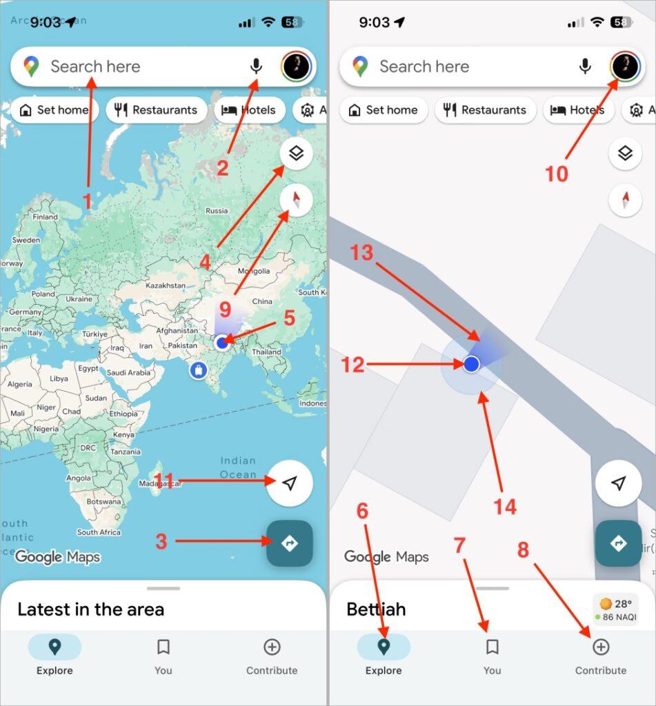
- Search Bar: The white bar at the top lets you search for any place, address, or landmark. You can type something like bars near me and get results.
- Microphone Icon (Voice Search): Tap this mic if you’d rather speak instead of typing. Just say nearest petrol pump, and Maps will find it for you.
- Directions Icon: The blue arrow-shaped icon opens the direction panel. You can set your starting point and destination to see routes.
- Layers / Map Type Icon: Found in the top-right corner, this icon lets you switch between map styles, like Default, Satellite, or Terrain.
- Your Location Icon: The small circular target at the corner centers the map to your current GPS position. It’s useful when you’ve scrolled away and want to come back to where you are.
- Explore Tab: This section shows what’s around you, like nearby restaurants, gas stations, or parks, all based on your current location.
- Saved or You Tab: This section lists all your saved places, like favorites, starred locations, or custom lists.
- Contribute Tab: The plus shape icon allows you to share your experience by adding reviews, photos, or new places.
- Compass Icon: Rotates your map view based on your phone’s direction. Red always points north.
- Profile Icon: Found on the top-right corner, this opens your account settings and saved lists.
- Map pin: After clicking on it, you can find you’re exact location.
- Blue Dot (Current Location Indicator): Represents exactly where you are on the map in real time.
- Blue Beam (Direction Facing Indicator): The small cone around your blue dot shows which direction your phone (and you) are facing.
- Circle Accuracy Indicator: If you notice a faint blue circle around your location dot, it shows your GPS accuracy range. If it’s smaller means more precise.
2. Search and History Screen Icons
Whenever you search for a new place or revisit an old one, these icons show up. This screen appears when you tap the Search Bar or open your previously searched history.

- Back Arrow: Takes you back to the main map view without closing the app.
- Clock Icon: A small clock beside previous searches. It shows your past searches for quick access.
- Microphone Icon: Works exactly as it does on the Home screen for voice-based search.
- Edit / More Icon: Lets you rename, change, or delete saved places like Home or Work.
- Info Icon: Gives you a short note explaining how Google uses your activity to improve search results.
- Clear History Icon: Lets you remove one or all of your previous search entries.
- Home Label Icon: Marks your saved Home address for easy navigation later.
- Work Label Icon: Marks your workplace location.
- Parking Icon: Appears when you’ve saved a parking spot. Tap it to view where you parked.
- Recent Searches Section: A small list showing your most recent search terms and locations.
3. Directions Input Screen Icons
Once you tap on Directions on Google Maps home Screen, you’ll see this screen. It helps you set where you’re starting and where you’re going, along with your preferred travel mode.
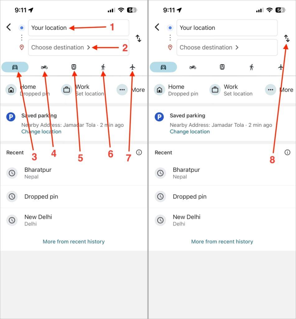
- Your Location Field: By default, it sets your current location as the starting point.
- Destination Field: Type or choose your desired location here.
- Car Mode: It is the default mode that gives the fastest route for cars.
- Bike Mode: Optimizes your route for cyclists, avoiding highways.
- Train / Transit Mode: Displays bus, metro, or train connections.
- Walk Mode: Shows pedestrian routes, footpaths, and shortcuts.
- Flight Mode: Suggests air routes between distant cities when applicable.
- Swap Location Icon (arrow icon): A two-arrow symbol that swaps your from and to locations instantly.
4. Route Preview Screen Icons
This screen appears just before you begin your trip, when Google Maps shows the overview of your entire route.
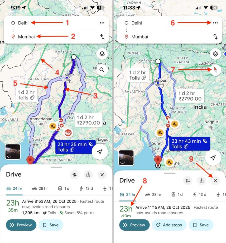
- Starting Point: Marks where your journey begins.
- Destination Point: The location you’re searched to reach.
- Blue Navigation Route Line: The main route, marked in blue, showing the suggested path.
- Traffic Color Indicators: Green means clear, orange means slow, and red means heavy traffic.
- Alternate Routes (Grey/Light Blue Line): Optional routes shown in grey, usually a little longer.
- Menu (Three Dots): Opens more settings, like Share, Edit Stops, or Route Options.
- Compass: Adjusts your map orientation.
- ETA Box (Estimated Time and Distance): Shows your travel time and distance.
- Cross Icon: Ends your route and returns to the home map.
5. Live Navigation Screen Icons
Once you hit Start after searching in any direction, Google Maps switches to live navigation mode. This screen is dynamic; it updates as you move and changes depending on where you are.

- Next Turn Direction Box: Tells you what your next move is, like Turn left after 200 meters.
- Current Position Arrow: Shows your car’s real-time position on the map.
- Recenter Button: If you move the map, this button repositions it to your car’s location.
- Route Line (Colored): Highlights your current route. The color may change based on traffic.
- Voice Command (Google Assistant): Helps you ask things like Find nearby fuel stations.
- Mute / Alerts / Full Voice Toggle: Adjusts the sound level of navigation prompts.
- Report Button: Lets you report live incidents.
- Exit Navigation Button: Stops the trip immediately.
- Route Overview Button: Gives a bird’s-eye view of your current route.
- Lane Guidance Arrows: Tell you which lane to stay in during turns or exits.
- Arrival Notification Icon: Appears when you’re nearing your final destination.
- Search Along Route: Helps you look for stops like restrooms or restaurants along your way.
- Speedometer Icon: Displays your current driving speed in real-time.
- Speed Limit Icon: Shows the maximum allowed speed for the current road.
6. Your Places on Google Maps
This section covers the places you’ve saved or marked yourself, like your favorite cafés, trips, or lists.
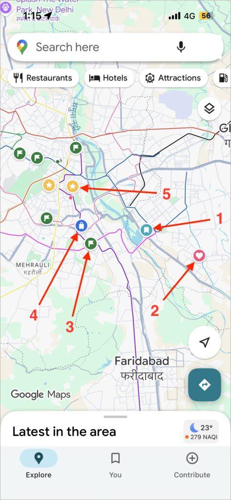
- Saved Places: The bookmark icon used for locations you’ve saved manually.
- Favorites: A heart icon marking your personal favorite spots.
- Want to Go: A green flag for destinations you’ve planned to visit later.
- Travel Plans: Used for upcoming or ongoing trips.
- Start Places: Indicates the start point of any saved route.
7. When You Click on a Place on Google Maps
When you tap any place on Google Maps, you’ll see several icons and symbols. Each tells you something important about that location. You just need to tap on any listed icons and you can see these symbols.
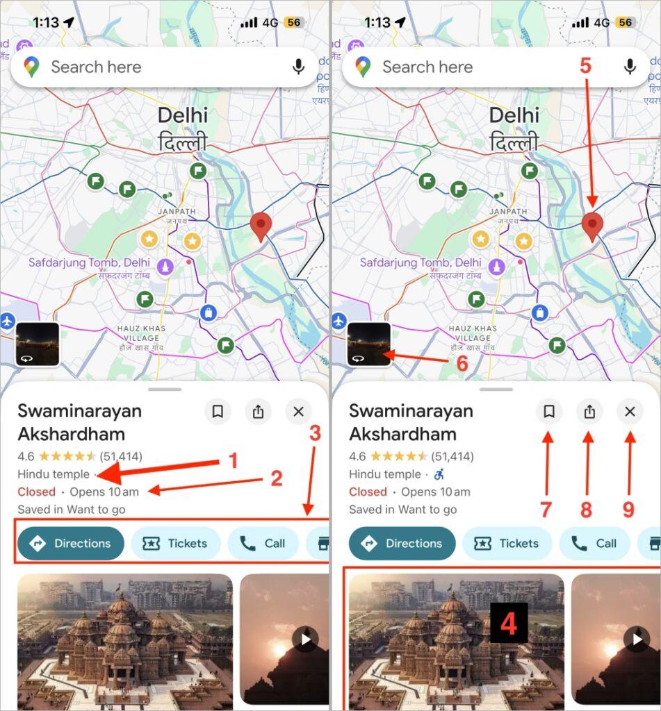
- Place Type: Tells what kind of place it is, like a temple, restaurant, museum, or park.
- Status Indicator (Closed · Opens 10 AM): Shows whether the place is currently open or closed and when it opens next.
- Action Buttons (Directions, Tickets, Call, etc.): These icons help you to open navigation with route, buy entry tickets, and contact the place directly, check their website, and more.
- Photos and Videos Section: Shows real photos or short clips uploaded by visitors or Google to preview the place.
- Red Location Pin on Map: Marks the exact location of the selected place on the map.
- Street View Preview (Square Image with Curved Arrow): Shows a real-world 360° image of the place captured by Google’s Street View cameras.
- Save Icon: Lets you save the place to your favorites or lists for quick access later.
- Share Icon: Let’s you share the location link with others through apps like WhatsApp and Messages.
- Cross Icon: Closes the place details and returns you to the main map view.
You may like to read: What Do Various Icons and Symbols Mean on WhatsApp
Category 2: In-Map Icons and Symbols on Google Maps
Google Maps uses over a hundred color-coded icons to represent roads, restaurants, temples, metro lines, monuments, and more, each designed to help you quickly identify what’s what.
I’ve grouped the icons into eight categories, each covering a specific location type with its look, meaning, and real-world example for easy reference.
1. Food and Drinks Icons
If you open Google Maps around any busy street, the first icons you’ll notice belong to food and beverages. These appear in orange tones. You can check from the image.
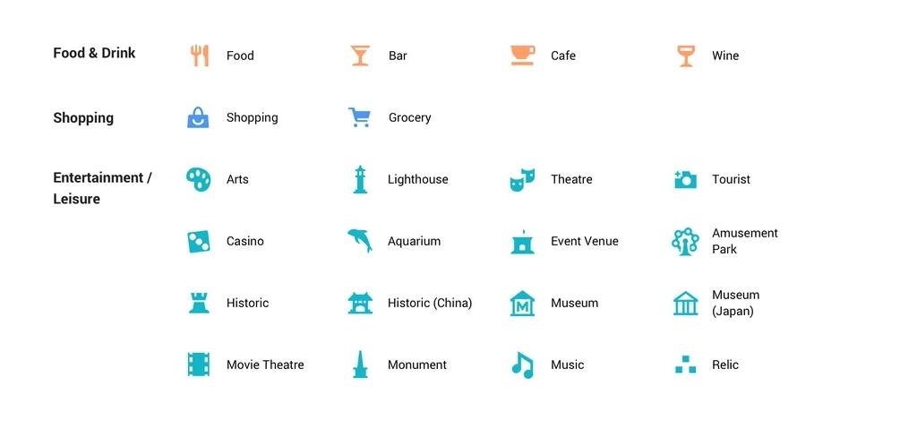
- Food: Represents restaurants or dining places serving meals.
- Bar: Indicates pubs, lounges, and other venues that serve alcohol.
- Cafe: Used for coffee shops or snack points, you can usually find it near workplaces and colleges.
- Wine: Shows wine bars
2. Shopping and Entertainment/Leisure Icons
This section covers everything related to shopping, art, culture, and recreation. These icons are often purple or red and appear around downtown areas and tourist spots.

- Shopping: Shopping malls or large retail stores.
- Grocery: Supermarkets or stores for daily essentials.
- Arts: Art galleries and cultural centers displaying artwork.
- Lighthouse: Tourist spots located near coastal areas featuring a lighthouse.
- Theatre: Live-performance theatres or auditoriums.
- Tourist: General tourist attractions or sightseeing points.
- Casino: Casinos and gambling establishments.
- Aquarium: Places displaying aquatic animals, for example, SEA LIFE Bangkok Ocean World.
- Event Venue: Large halls or open grounds hosting public or private events.
- Amusement Park: Theme parks and major recreational areas like Disneyland or Essel World.
- Historic: General historical landmarks such as forts or old city ruins.
- Historic (China): historic Chinese structures, for instance, parts of the Great Wall of China.
- Museum: Standard museums exhibiting art, science, or culture.
- Museum (Japan): Museums with Japanese architecture or cultural focus, like Tokyo National Museum.
- Movie Theatre: Cinemas and movie halls.
- Monument: Statues or major commemorative structures, for example, the Statue of Liberty or India Gate.
- Music: Music venues, concert halls, or clubs hosting live performances.
- Relic: Represents archaeological sites preserving ancient remains, such as Mohenjo-daro or Pompeii.
In case you missed: Telegram Icons Explained: What Every Symbol Really Means
3. Services and Health Icons
These icons relate to day-to-day facilities like banks, hotels, medical centers, and essential services. These are represented with a light purple color.
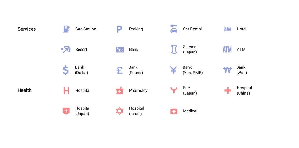
- Gas Station: Fuel pumps or service stations.
- Parking: Public or private parking areas.
- Car Rental: renting cars or vehicles.
- Hotel: Hotels or guesthouses.
- Resort: Leisure resorts or vacation stays.
- Bank: General banking branches.
- ATM: Automated teller machines for cash withdrawal.
- Bank (Dollar/Pound/Yen/Won): Banks using respective currencies.
- Service (Japan): Designates service centers in Japan, like highway service areas.
- Hospital: General hospitals providing full medical care.
- Pharmacy: Medical or drug stores.
- Fire (Japan): Fire stations marked with Japanese characters.
- Hospital (China): Hospitals within China; the icon appears with a regional design.
- Hospital (Japan): Japanese hospitals.
- Hospital (Israel): Hospitals within Israel
- Medical: General medical or first-aid facilities, smaller than hospitals.
Must Read: Snapchat Emoji Meanings and All Symbols Explained
4. Outdoor and Transport Icons
Used for natural spots, outdoor activities, and every form of transportation.
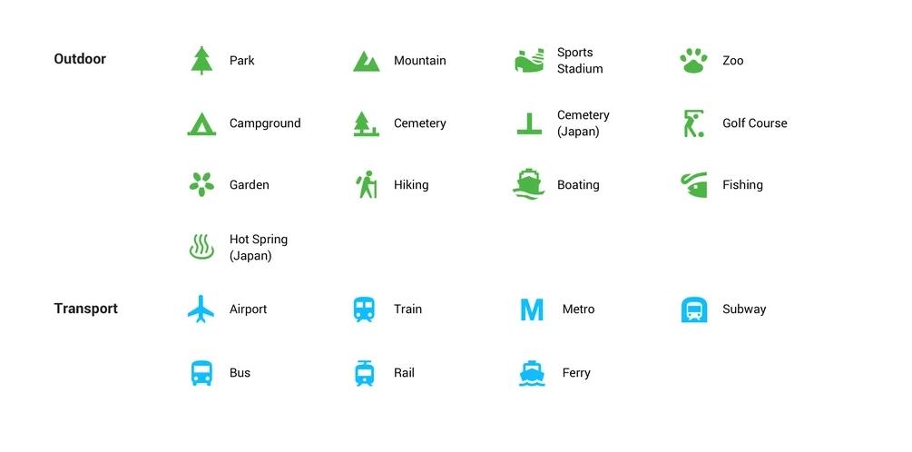
- Park: Public parks and gardens.
- Mountain: Mountain or hill ranges.
- Sports Stadium: Stadiums or sports complexes, like Wembley Stadium (London).
- Zoo: Zoos or wildlife enclosures.
- Campground: Camping or RV parks.
- Cemetery: General cemeteries.
- Cemetery (Japan): Japanese-style cemeteries, often shown with a pagoda-like icon.
- Golf Course: Golf playing fields.
- Garden: Botanical or ornamental gardens.
- Hiking: Hiking and trekking routes; for example, Manali Himalayan Trail.
- Boating: Boat docks or marinas for water activities.
- Fishing: Fishing spots, lakes, or riverbanks.
- Hot Spring (Japan): Natural hot-spring resorts (onsen) in Japan, such as Hakone Onsen.
- Airport: Airports and terminals.
- Train: Train stations for regional trains.
- Metro: Metro or underground transit stops.
- Subway: icon for subway systems or stations.
- Bus: Bus stops or main bus depots.
- Rail: Tram or light-rail stations.
- Ferry: Ferry terminals or docks.
5. Civil Services and Public Buildings
These icons highlight government and civic institutions that help in public administration.

- Civic Building: Town halls or administrative offices.
- Post Office: Postal service offices.
- Post Office (Japan): Japanese postal branches marked with red “〒”.
- Library: Public libraries and archives.
- Police: Police stations.
- Police (Japan): Japanese Kōban (police boxes).
- School: Schools and educational institutions.
- School (Japan): Japan-specific school marker.
- Bridge: bridges, for example, the Golden Gate Bridge (San Francisco).
- Restroom: Public toilets, usually in parks or stations.
- City Office (Japan): City-level government offices in Japan.
- Civil Office (Japan): Local civic administration offices.
- Government (China): Chinese government buildings such as city halls.
- Miscellaneous: Any other general public service area not falling in other categories.
6. Worship and Religious Sites
You’ll find these icons when zooming into areas dense with religious places or heritage structures.
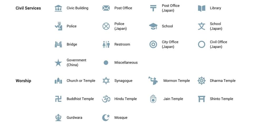
- Church/Temple: Christian or interfaith temple icon.
- Synagogue: Jewish houses of worship.
- Mormon Temple: LDS (Church of Jesus Christ of Latter-day Saints) temples.
- Dharma Temple: Buddhist or dharma-related temples.
- Buddhist Temple: Specific Buddhist temples like Wat Pho in Bangkok.
- Hindu Temple: Hindu mandirs, e.g., Akshardham Delhi.
- Jain Temple: Jain derasars are found across India.
- Shinto Temple: Shinto shrines in Japan, e.g., Meiji Shrine in Tokyo.
- Gurdwara: Sikh temples like the Golden Temple in Amritsar.
- Mosque: Muslim mosques such as the Jama Masjid in Delhi.
7. Personal and Road Condition Icons
These icons are personal to each user or show road events that affect navigation.
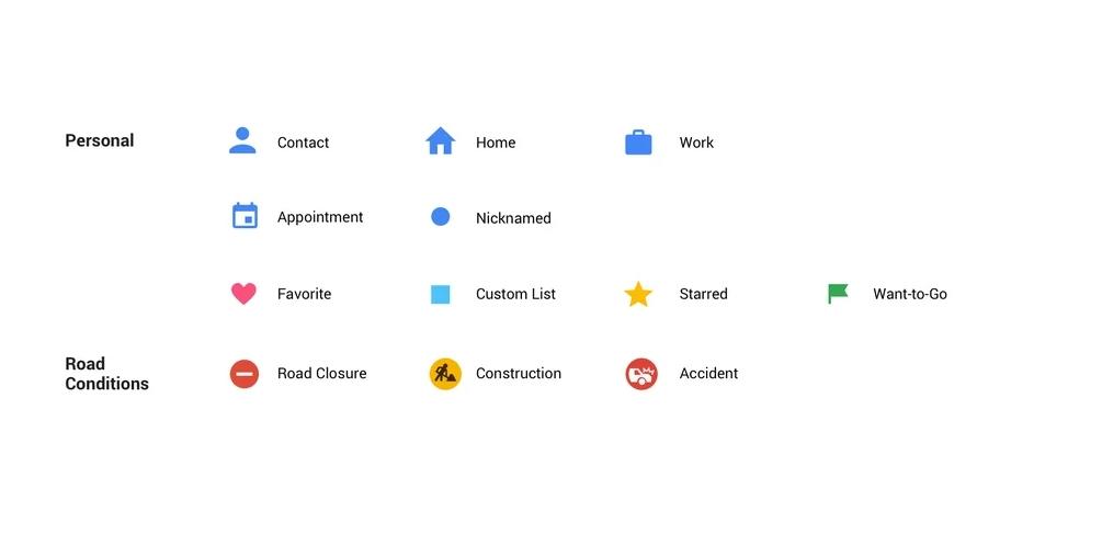
- Contact: A location saved for a contact in your list.
- Home: Your saved home address.
- Work: Your saved work location.
- Appointment: Calendar or meeting location synced from Gmail.
- Nicknamed: A custom-named place.
- Favorite: Heart-marked places you like.
- Custom List: Custom list of saved places.
- Starred: Star-saved important places.
- Want-to-Go: Marked with a flag for future visits.
- Road Closure: Shows a blocked or closed road.
- Construction: Shows an ongoing roadwork zone.
- Accident: Displays a crash reported by users.
8. Boundaries and Public Transport Lines
These are lines and borders instead of standalone icons; they help define boundaries and transit paths.

- Metro / Train Route (Colored Line): Represents metro or train lines.
- Subway / Tram / Bus / Ferry Routes: Different colored lines for each public transport type.
- City / Area Boundary (Red Dotted Line): When you click on any city, area, state, or country name, the red dotted line defines its limits.
- State Boundary: Shows state borders.
- Country Border: Marks international borders.
- Toll Road Symbol: Appears on highways requiring toll payment.
- Highway Shield Symbol: Indicates national or interstate highways, labeled with numbers (e.g., NH 27 or I-95).
Conclusion
I’ve covered the key Google Maps icons and symbols. Once you know what they mean, navigating gets much easier. Hopefully, this guide helped clear up any confusion. Have questions or thoughts? Share them in the comments below.
FAQs
Because Google customizes its icons based on region, certain symbols, especially for banks, hospitals, or postal services, change design based on local standards, like in China and Japan.
Closed or restricted roads appear with a red line or a barricade symbol.
Tap and hold on the location, scroll up the info sheet, and select Suggest an edit or Add a missing place.
No, you can’t add custom icons for public viewing. But you can create custom lists and mark places with stars, flags, or hearts. Also, if you have any Business, then you can list on Google Maps.
There’s no fixed schedule, but icons are updated regularly about every 6 months whenever Google refreshes regional map data.
When you tap the name of any area, city, state, or country in Google Maps, only then will you see the red dotted line appear around it. This red line highlights the exact boundary of the selected location.
You might also like:

